Antuco walking map | wandelkaart 1:30.000


€9,95
direct leverbaar!
- Zeer ruim assortiment
- Verzending 1-2 werkdagen
- Niet tevreden, geld terug
- Ruilen binnen 14 dagen
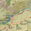
Antuco - Laguna del Laja National Park - Volcán Antuco - Sierra Velluda area at 1:30,000 in a series of contoured, GPS compatible trekking and exploration maps at various scales form Trekkingchile.
The map has contours at 50m intervals, with graphics/colouring to show glaciers and different types of vegetation. Road network indicates paved or gravel roads and dirt tracks. The map shows trekking routes with distances and symbols highlight various places of tourist interest: campsites, cabins and other types of accommodation, restaurants, animal observation points, fishing tours and boat trips, etc. Coverage extends from Abanico to the lake and north/south from the Lagunas Las Cóndores pass to the peak of Cordón Petronquines. The map has a UTM grid and latitude longitude margin ticks at 1'. Map legend includes English.
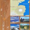
On the reverse are colour drawings of local fauna plus several English language advertisements for various services. Maps in the Trekkingchile series use satellite imagery as a base, with contour lines and colouring to indicate different types of terrain and habitats. Unless indicated to the contrary in the individual descriptions, the maps have a UTM grid, plus margin ticks for latitude and longitude. The maps are annotated with tourist information and most titles include a street plan of the region's main town. Many are illustrated with drawings of local fauna or flora. Map legends and other text include English. To see the other titles in this series please click on the series link.
-
 Trekking Map Condor Circuit 1:50 000 *direct leverbaar!€6,90 > alles van Zuid-Amerika (en Antarctica)
 -
 Chile & Easter Island Eyewitness Travel GuideEngelstalige Capitoolgids. Bijzonder fraaie en complete gidsen, waarin de illustraties de kern vormedirect leverbaar!€23,90 > alles van Zuid-Amerika (en Antarctica)
 -
 Adventure map Central Chile & Argentina 1:500.000Professioneel gemaakte kaart, met ondersteuning van de Technische Universiteit Dresden (Kartographisdirect leverbaar!€19,95 > alles van Zuid-Amerika (en Antarctica)
 -
 Chili landkaart, wegenkaart 1:1.600.000Uitstekende tweezijdig bedrukte wegenkaart / overzichtskaart. Verschenen in de serie van het 'Worlddirect leverbaar!€11,95 > alles van Zuid-Amerika (en Antarctica)
 -
 Melado Volcan San Pedro 1:50.000 *Eerste trekking kaart van het zuidelijk van de Río Maule gelegen wandel en paardrijparadijs rondomdirect leverbaar!€9,95 > alles van Zuid-Amerika (en Antarctica)
 -
 I love the seaside: ChileI Love the Seaside, dé reisgidsreeks voor surfers en iedereen die van de kust houdt, neemt je in dedirect leverbaar!€29,95 > alles van Zuid-Amerika (en Antarctica)
 -
 1:50 000 9789568925086 Viachile Editores Trekking Maps Wandelkaarten Chili") Trekking Map Rapa Nui (Paas Eiland) 1:50 000Toeristische kaart van Paaseiland met alle wandel- en fietsroutes. Met GPS info. Alle toeristische bdirect leverbaar!€19,95 > alles van Zuid-Amerika (en Antarctica)
Trekking Map Rapa Nui (Paas Eiland) 1:50 000Toeristische kaart van Paaseiland met alle wandel- en fietsroutes. Met GPS info. Alle toeristische bdirect leverbaar!€19,95 > alles van Zuid-Amerika (en Antarctica) -
 Travels in a thin country'Notably well written, perceptive, lively and sympathetic. She catches the elusive character of Chilniet direct leverbaar€15,35 > alles van Zuid-Amerika (en Antarctica)
 -
 Antuco walking map | wandelkaart 1:30.000Antuco - Laguna del Laja National Park - Volcán Antuco - Sierra Velluda area at 1:30,000 in a seriedirect leverbaar!€9,95 > alles van Zuid-Amerika (en Antarctica)
 -
 ITM Zuid-Chili en Patagonie | landkaart, autokaart 1:2.200.000 / 750.000Fraaie, relatief gedetailleerde overzichtskaart. Veel kaarten uit deze serie hebben op de achterkantdirect leverbaar!€13,95 > alles van Zuid-Amerika (en Antarctica)
 -
 der Norden - 20 Wandertouren 9783831725892 Reise Know-How Verlag Wandelgidsen Chili") Chile (Chili) der Norden - 20 WandertourenNeben den Wanderungen auf verschiedenen Höhenlagen enthält dieser Wander- und Bergführer eine Ausniet direct leverbaar€19,50 > alles van Zuid-Amerika (en Antarctica)
Chile (Chili) der Norden - 20 WandertourenNeben den Wanderungen auf verschiedenen Höhenlagen enthält dieser Wander- und Bergführer eine Ausniet direct leverbaar€19,50 > alles van Zuid-Amerika (en Antarctica) -
 9781787016767 Lonely Planet Travel Guides Reisgidsen Chili") Lonely Planet Chile & Rapa Nui (Easter Island)Goede gidsen voor trekkers. Na info over land en volk, en reisvoorbereidingen volgen beschrijvingendirect leverbaar!€25,95 > alles van Zuid-Amerika (en Antarctica)
Lonely Planet Chile & Rapa Nui (Easter Island)Goede gidsen voor trekkers. Na info over land en volk, en reisvoorbereidingen volgen beschrijvingendirect leverbaar!€25,95 > alles van Zuid-Amerika (en Antarctica)